Updated Demo Reel!
I have not updated my demo reel since I started working at Universal Creative.. A new updated demo reel is in progress to demonstrate the kind of work I did there, without actually releasing any Universal content to the public.
Coming Soon!Environment Demo Reel!
There is quite a lot of content shown in my portfolio, so I followed a colleague's advice and created the concise demo reel that I've been putting off for "when I had the time." Well the time is finally now...
Read more…
Washington, DC
It's an ambitious project, but I might be able to pull this one off with the right software. The Office of the Chief Technology Officer of Washington, DC maintains a thorough and up-to-date catalog of GIS data covering the entire district. This includes buildings, roads and various other features that I only need to integrate, saving me alot of digitization time.
Read more…
Dynamic Real-time Terrain (DyRT)
I've been working on a WYSIWYG terrain editor that procedurally generates terrain from GIS data, but also allows edits to be made through the interface with real-time visual feedback. So far, I've only gotten the renderer working with some minor editing capabilities. Namely Push/Pull surface features and texture blending.
Read more…
Fort Leonard Wood, MO
The CDT trainer provides effective and affordable training for US Army drivers and crews of a wide range of heavy vehicles. The CDT delivers demanding driver experiences in immersive virtual environments, such as this 480 square kilometer highly detailed representation of the US Army Base in Fort Leonard Wood, MO. The terrain includes geospecific paved, gravel and dirt roads, all buildings within the gaming areas, traffic signs, traffic lights and even decorative elements found at the real location, such as historical display vehicles, flag poles and road obstacles.
Read more…
Camp Shelby, MS
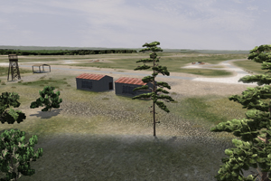
This latest 300 square kilometer terrain includes paved and gravel roads, buildings, battle position berms, target models and water hazards. The 3D terrain database closely approximates the MPRC training range at the US Army base in Camp Shelby, MS with the latest GIS data available. The immersive environment provides a training platform to qualify gunnery trainees safety and operation procedures before entering a true live fire situation.
Read more…


